Westward Gold Inc. (CSE: WG, OTCQB: WGLIF, FSE: IM50) (“Westward” or the “Company”) is pleased to provide an update on diamond drilling currently underway at the Company’s Toiyabe Gold Project in Lander County, Nevada (“Toiyabe”), pursuant to Westward’s previously-announced private placement and strategic transaction with EMX Royalty Corporation (“EMX”) (see press releases dated February 15th and 23rd, 2023 for additional information).
Drill hole T2301 has reached its initial planned total depth (“TD”) of 500 meters (~1640 feet), and the decision has been made to continue drilling deeper. The first 245 meters (800 feet) of core have now been cut and shipped to Bureau Veritas’ (“BV”) lab in Elko, NV, and deliveries will continue on a regular basis over the coming weeks. BV has communicated to the Company that the expected lab turnaround time will be approximately 3 weeks.
Colin Moore, Westward’s President & CEO, commented: “We’d like to thank leadership at EMX and their drilling subsidiary Scout Drilling LLC for what has been a truly collaborative effort to date. This included acquiring the additional rods necessary to allow drilling to reach a greater depth than originally planned, based on feedback from our technical team.”
Click the graphic below for a high level video summary which accompanies this news release:
At this time, the Company is pleased to provide additional technical information and visual results from T2301 thus far. Westward stresses that the core images disclosed herein are for context only as examples of the geologic findings described in this news release; the Company is not making any inferences as to the potential gold mineralization of these select intervals, nor should any such inferences be made by investors in the absence of full assay results which are expected before the end of the second quarter of 2023.
T2301 was designed to accomplish three primary goals:
- Follow up and verify historical, near-surface gold assays (including 10.7m of 2.47 g Au/t from 7.6 to 18.3m, and 15.2m of 0.80 g Au/t from 22.9 to 38.1m)(1) and geology in reverse-circulation (“RC”) drill hole T802
- Confirm favourable lower plate carbonate stratigraphy downdip to the northeast, in a zone that has never been explored at depth, and
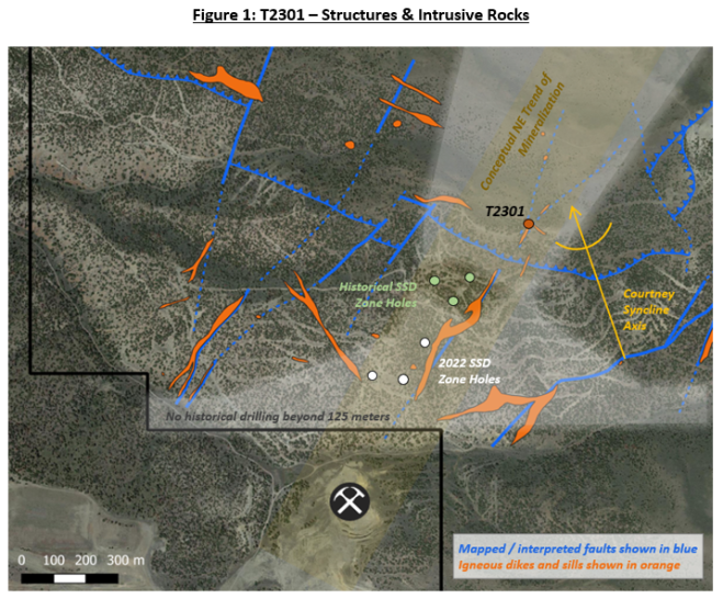
- Test for continuity of the SSD Zone target where a northeast-trending structure (the “Diamond Fault”) and a syncline (the “Courtney Syncline”) intersect at depth. T2301 represents a 295-meter northeast step-out from the closest intersection of the thick, mineralized deformation zone known as the SSD Zone (legacy hole T1002 intersected 33.8m of 1.16 g Au/t from 292.4m depth(1)).
The first 500 meters of recovered core have demonstrated that favorable lower plate carbonate stratigraphy continues, and that the hydrothermal system appears to increase in strength towards the northeast. These observations led to the technical team’s decision to continue the hole beyond the original TD. The upper place siliciclastic rock package is host to multiple intervals of hydrothermal alteration including oxidized, silicified and clay-altered breccias (see Figure 2). This pervasive hydrothermal alteration continues into the lower plate carbonate rocks, with attributes of the T2301 core being reminiscent of features observed in the SSD Zone: several thick zones of intense brecciation, decalcification, silicification, and oxidation including but not limited to the following intervals:
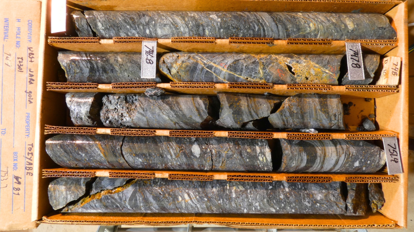
- 781 to 941.7 feet (238 to 287 meters) with moderate decalcification, clay, and oxidation (see Figure 3)
- 1152.5 to 1388 feet (351 to 423 meters) with intense brecciation associated with decalcification, increased clay intensity, and minor oxidation and silicification
- 1405.5 to 1488 feet (428 to 453.5 meters) with intense decalcification and silicification with moderate to intense brecciation and minor oxidation
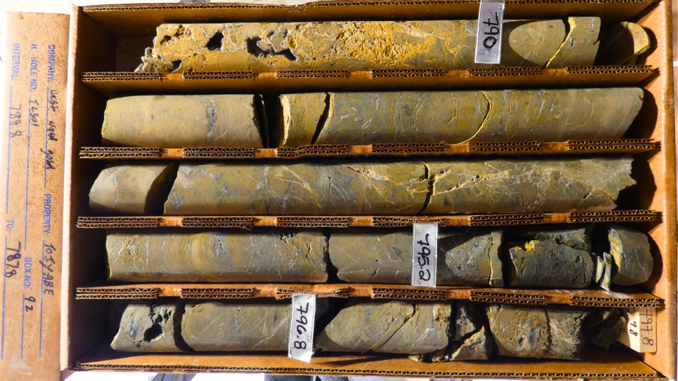
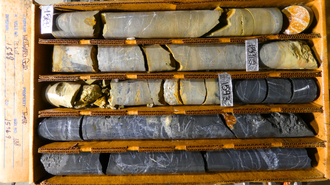
- 1507.8 to 1606 feet (459.5 to 489.5 meters) with intense decalcification, moderate to intense brecciation and silicification, and moderate to intense oxidation that increases with depth (see Figure 4)
Figure 2: 744 to 753.7 feet 226.8 to 229.7 meters (note units shown in photo are in feet)
Dave Browning, Westward’s Vice President Exploration, noted: “We could tell we were tapping into a geologically interesting area when we began to see massive zones of shearing, veining, oxide, and clay in the upper plate. These features are associated with major thrust faults such as the Roberts Mountains Thrust. The amount of alteration observed in the siliciclastic upper plate speaks to the potential of the system we are chasing.”
Figure 3: 788.8 to 797.8 feet 240.4 to 243.2 meters (note units shown in photo are in feet)
Steve Koehler, Technical Advisor, commented: “Vertically-extensive zones of hydrothermal alteration as observed in T2301 are geologic characteristics you like to see in early-stage, step-out holes. The oxidation and decalcification observed around the original TD of 500m indicates the Carlin-type hydrothermal system is still present at depth and advancing T2301 is warranted to fully test the target.”
Figure 4: 1588 to 1596.9 feet 484 to 486.7 meters (note units shown in photo are in feet)
Sampling Methodology, Chain of Custody, Quality Control and Quality Assurance “QA/QC”
The Company is implementing a best-practices QA/QC program during the ongoing drilling campaign. All core cutting and sampling is conducted under the supervision of the Company’s Vice President Exploration or Project Geologist, and the chain of custody from the project to the sample preparation facility was continuously monitored. Samples were transported directly from the company’s core cutting facility in Crescent Valley, NV by Westward Gold personnel to BV’s certified preparation facility in Elko, NV, where they are crushed and pulverized. Resulting sample pulps are transported to BV’s certified facilities in Sparks, NV for fire assay and Vancouver, BC, for multielement analysis.
Core samples intervals are determined based on geological observations from the technical team. Certified standards and blanks are inserted every 10 samples. All samples will be analyzed for gold, silver, and 35 additional elements. Assays will consist of fire assay / AAS for gold, and Aqua Regia ICP-ES/MS for geochemistry.
Drill hole deviation will be measured by gyroscopic down-hole surveys with tooling provided by REFLEX of Elko, NV. The deviation surveys will provide accurate data about the true inclination and azimuth of the holes. Obtaining an accurate survey of the drillholes leads to a better contextual understanding of the core samples, and a more robust 3D geological model.
(1) Sources: Toiyabe data room and drill log files inherited from previous operators. The Company and its qualified person have relied on third-party data during its review of the information presented herein, and while it believes the information to be relevant to investors, it cautions readers that it should not be unduly relied upon in drawing inferences on the mineralization at Toiyabe, as additional work is required to confirm drill intercepts and/or soil samples, including (but not limited to): re-sampling and re-assaying of available core and/or pulps, verification of assay certificates where available, review and verification of drillhole geologic logs versus the preserved core and RC cuttings.
Qualified Person
The technical information contained in this news release was reviewed and approved by Steven R. Koehler, Technical Advisor to the Company, who is a Qualified Person under National Instrument 43-101 – Standards of Disclosure for Mineral Projects. Mr. Koehler is a Certified Professional Geologist (CPG) through the American Institute of Professional Geologists (AIPG).
About Westward Gold
Westward Gold is a mineral exploration company focused on developing the Toiyabe, Turquoise Canyon, and East Saddle Projects located in the Cortez Hills area of Lander County, Nevada, and the Coyote and Rossi Projects located along the Carlin Trend in Elko County, Nevada. From time to time, the Company may also evaluate the acquisition of other mineral exploration assets and opportunities.
For further information contact:
Colin Moore
President, CEO & Director
Westward Gold Inc.
colin@westwardgold.com
www.westwardgold.com
The Canadian Securities Exchange has neither approved nor disapproved the contents of this news release. The Canadian Securities Exchange does not accept responsibility for the adequacy or accuracy of this news release.
This news release contains or incorporates by reference “forward-looking statements” and “forward-looking information” as defined under applicable Canadian securities legislation. All statements, other than statements of historical fact, which address events, results, outcomes, or developments that the Company expects to occur are, or may be deemed, to be, forward-looking statements. Forward-looking statements are generally, but not always, identified by the use of forward-looking terminology such as "expect", "believe", "anticipate", "intend", "estimate”, “potential”, “on track”, “forecast", "budget", “target”, “outlook”, “continue”, “plan” or variations of such words and phrases and similar expressions or statements that certain actions, events or results “may”, “could”, “would”, “might” or “will” be taken, occur or be achieved or the negative connotation of such terms.
Such statements include, but may not be limited to, information as to strategy, plans or future financial or operating performance, such as the Company’s expansion plans, project timelines, expected drilling targets, and other statements that express management’s expectations or estimates of future plans and performance.
Forward-looking statements or information are subject to a variety of known and unknown risks, uncertainties and other factors that could cause actual events or results to differ from those reflected in the forward-looking statements or information, including, without limitation, the need for additional capital by the Company through financings, and the risk that such funds may not be raised; the speculative nature of exploration and the stages of the Company’s properties; the effect of changes in commodity prices; regulatory risks that development of the Company’s material properties will not be acceptable for social, environmental or other reasons, availability of equipment (including drills) and personnel to carry out work programs, that each stage of work will be completed within expected time frames, that current geological models and interpretations prove correct, the results of ongoing work programs may lead to a change of exploration priorities, and the efforts and abilities of the senior management team. This list is not exhaustive of the factors that may affect any of the Company’s forward-looking statements or information. These and other factors may cause the Company to change its exploration and work programs, not proceed with work programs, or change the timing or order of planned work programs. Additional risk factors and details with respect to risk factors that may affect the Company’s ability to achieve the expectations set forth in the forward-looking statements contained in this news release are set out in the Company’s latest management discussion and analysis under “Risks and Uncertainties”, which is available under the Company’s SEDAR profile at www.sedar.com. Although the Company has attempted to identify important factors that could cause actual results to differ materially, there may be other factors that cause results not to be as anticipated, estimated, described or intended. Accordingly, readers should not place undue reliance on forward-looking statements or information. The Company’s forward-looking statements and information are based on the assumptions, beliefs, expectations, and opinions of management as of the date of this press release, and other than as required by applicable securities laws, the Company does not assume any obligation to update forward-looking statements and information if circumstances or management’s assumptions, beliefs, expectations or opinions should change, or changes in any other events affecting such statements or information.

