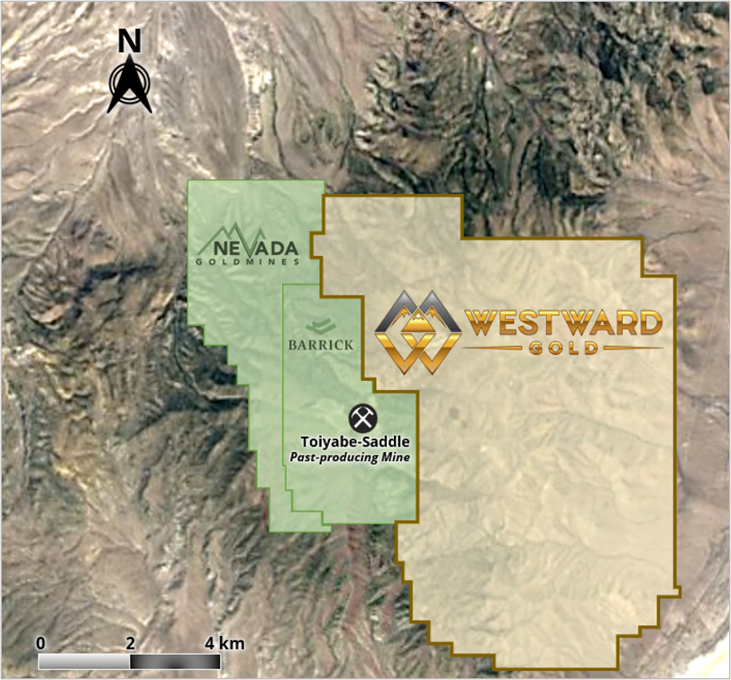
Projects

Toiyabe

Overview

The Toiyabe Project is an advanced exploration asset consisting of approximately 1,400 hectares of public land, administered by the Bureau of Land Management. 165 unpatented mining claims cover the region. 

Other highlights include:

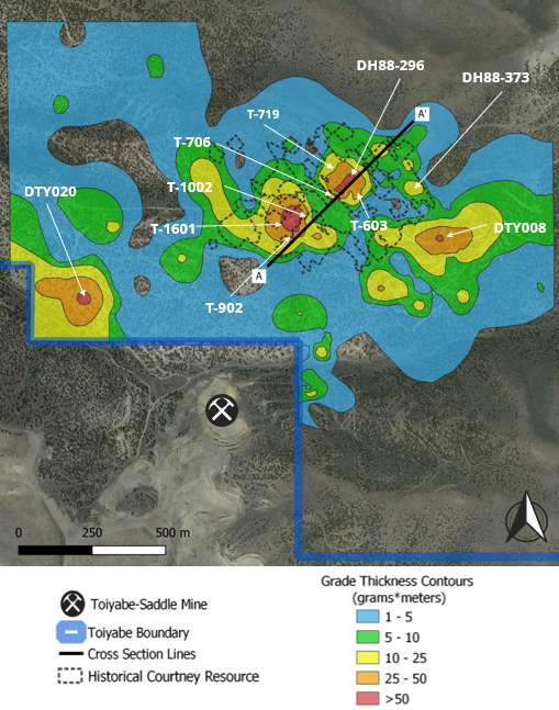
  • Favourable stratigraphy associated with anomalous gold at surface and drill intercepts
  • Existing targets untested laterally and at depth 
  • Untested targets associated with surface geochemical anomalies, favourable stratigraphy, and structural controls
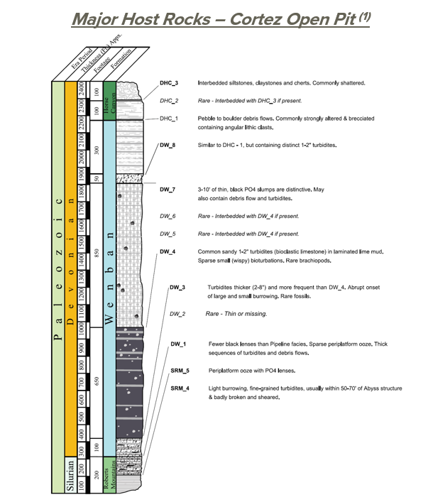
(1) NI 43-101 Technical Report, IM Exploration Inc., Prepared by Donald E. Cameron, P.Geo, August 5, 2021


HISTORIC RESOURCE & NOTABLE INVERVALS

Early drilling of the Courtney Zone historical resource demonstrated near surface high-grade mineralization including:

  • DH88-373: 67.1m @ 0.88 g Au/t, from surface (incl. 21.3m @ 2.1 g Au/t)
  • DH88-296: 19.8m @ 4.03 g Au/t, from surface (incl. 13.7m @ 5.54 g Au/t)
  • DTY020: 15.2m @ 0.72 g Au/t from surface, and 36.6m @ 1.12 g Au/t from a depth of 19.8m
  • T-603: 18.3m @ 4.47 g Au/t, from a depth of 38.1m (incl. 6.1m @ 12.85 g Au/t)
  • T-706C: 16.8m @ 3.66 g Au/t, from a depth of 47.2m (incl. 7.6m @ 7.37 g Au/t)
  • T-719: 27.4m @ 2.21 g Au/t, from a depth of 45.7m (incl. 9.1m @ 5.45 g Au/t)

Wider intervals at greater depth indicate widespread disseminated gold mineralization:

  • DTY008: 22.9m @ 1.62 g Au/t, from 103.6m (incl. 15.2m @ 2.20 g Au/t)
  • T-902C: 42.7m @ 1.37 g Au/t (from 266.7m)
  • T-1002BC: 33.8m @ 1.16 g Au/t (from 292.4m)
  • T-1601C: 25.9m @ 1.01 g/t (from 278.4m)

Only 16% of drill holes at Toiyabe reached beyond 180 meters: expansion potential at depth

Sources: NI 43-101 Technical Report, IM Exploration Inc., Prepared by Donald E. Cameron, P.Geo, August 5, 2021; Toiyabe data room and drill log files inherited from previous operators. The Company and its qualified person have relied on third-party data during its review of the information presented herein.


MINERALIZATION CONTROLS

Previous Carlin-type deposit exploration models placed importance on high-angle faults as mineralizing structures.

Recent work by Rhys et al (2015) (1) demonstrated the role of compressional structures (thrust faults) on Carlin-type mineralization.

Reinterpretation of previous drilling efforts has identified compressional features throughout the Toiyabe project, particularly at the Wenban / Roberts Mountains formational contact – a feature commonly seen in the Cortez Trend.

Folds from compressional structures have created repetitive stratigraphy of host rocks, with extensional horst and graben features increasing its lateral extent.

Source: NI 43-101 Technical Report, Starcore International Mines Ltd., Prepared by Paul D. Noland, P.Geo., May 11, 2018
(1) “Controls of Fault and Fold Geometry on the Distribution of Gold Mineralization on the Carlin Trend”, David Rhys et al, 2015


HYPERSPECTRAL CORE IMAGING

High-resolution RGB (true colour) and infrared hyperspectral imagery of legacy core and chip trays from the Toiyabe Project (approximately 3,050m of diamond core and 11,900m of RC chips), completed fall of 2021

4 key alteration types associated with mineralization:
                (A) Fault-controlled mineralization
                (B) Carbonate lithology proximal to structure
                (C) Carbonate lithology distal to structure
                (D) Quartz veining with argillic alteration

Alteration identification led to new interpretation of mineralizing structures such as thrust faults

New understanding of relationship between gold mineralization controls and alteration type aiding current drill targeting

Mineralization “spectral fingerprint” allows geologists to identify system characteristics in real time on future drill campaigns

THE NEXT CARLIN-TYPE DISCOVERY?

✓ Same orientation and style of mineralization controls

 ✓ Same structural setting as major Cortez Deposits

✓ Intrusives (dikes / sills) present

✓ Mineralization open in multiple directions

✓ High grade gold present

TARGET ZONES

  • Histroical resource at Courtney Zone not tested to depth, despite evidence of more widespread dissemination into host rock (84% of holes ended within 180 meters from surface)
  • Anomalous soils associated with previously-identified California and Blind Zones
  • Courtney, California and Blind Zones associated with Roberts Mountain Thrust
  • Blind Zone tested with 11 drillholes, with a maximum depth of 135 meters (average depth of 100m)
  • California Zone tested with 81 drillholes, with only 12% extending beyond 180 meters

Technical Reports

2021 Toiyabe Gold Project NI 43-101
2018 Toiyabe Gold Project NI 43-101