Projects

Exploration Activities

2022

Phase 1 Drill Program

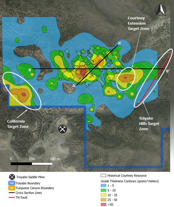
  • Large areas of open mineralization identified outside of the historical resource at the Courtney Zone
  • Completion of drill hole grade thickness map which contributed to the identification of E-W and NW-SE trends of mineralization at Toiyabe
  • Open mineralization will be tested in step-out drilling
  •  ~4,000m initial program planned


Historical Drilling Review Target Generation

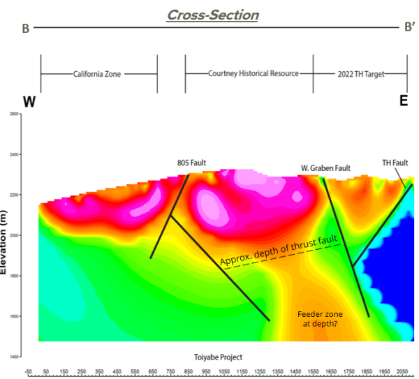
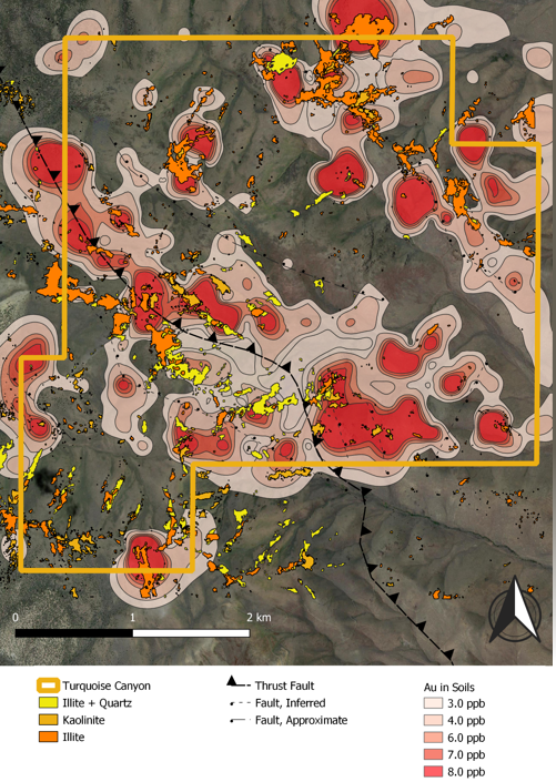
  • Historic drill logs and assays have been integrated with modern gravity, IP, and hyperspectral datasets
  • Reinterpretation and new understanding of lithologic/stratigraphic and structural controls on mineralization

➢ Toiyabe Hills Fault is associated with the contact of Upper and Lower Plate formations, a common mineralized zone in Carlin deposits
➢ Silica alteration in the form of Jasperoid discovered along the fault trace during site visit, a key indicator of hydrothermal activity
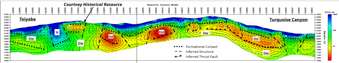
➢ IP data shows intersection of W. Graben Fault, known to be associated with the historical Courtney resource, and the TH Fault


Reprocessed Gravity Data

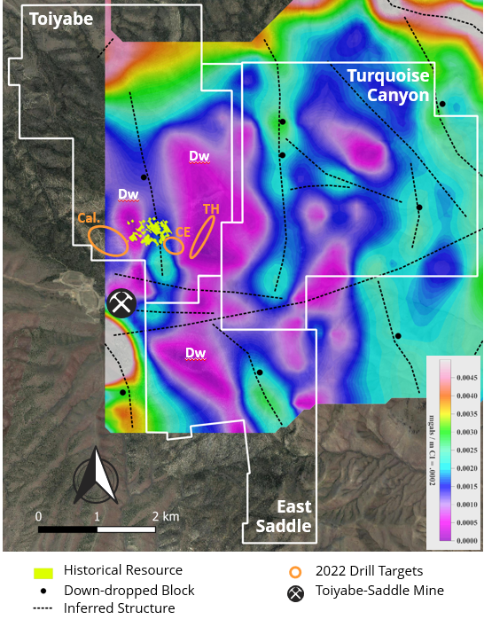
  • Previous regional-scale gravity survey reprocessed at a more localized level for improved data resolution and targeting
  • Historical Courtney resource hosted in outcropping Wenban Formation (“Dw”) along Horst and Graben structure

➢ The associated gravity anomaly was also identified to the east and south of the historical Courtney resource

  • Toiyabe-Saddle Mine hosted in same down-dropped block as historical Courtney resource
  • TH Target will test new Dw block → no previous drilling
  • California and CE Targets will test structures associated with Horst and Graben features, just as in the historical Courtney resource

2021

Hyperspectral Core Imaging

  • High-resolution RGB (true colour) and infrared hyperspectral imagery of legacy core and chip trays from the Toiyabe Project (approximately 3,050m of diamond core and 11,900m of RC chips), completed fall of 2021
  • 4 key alteration types associated with mineralization:
    1. Fault-controlled mineralization
    2. Carbonate lithology proximal to structure
    3. Carbonate lithology distal to structure
    4. Quartz veining with argillic alteration
    5. Alteration identification led to new interpretation of mineralizing structures such as thrust faults
  • New understanding of relationship between gold mineralization controls and alteration type aiding current drill targeting
  • Mineralization “spectral fingerprint” allows geologists to identify system characteristics in real time on future drill campaigns


Airborne Hyperspectral Survey

  • High ground resolution infrared imaging across multiple wavelength ranges to capture a broad array of mineralogy (completed fall of 2021)
  • 35 km2 total aerial coverage (focused on TC but also including Toiyabe historical resource, ToiyabeSaddle Mine, and northern areas of East Saddle)
  • Clays commonly associated with Carlin deposits present at:

➢ Courtney historical resource

➢ Toiyabe-Saddle open pits

➢ Turquoise Canyon

  •  Clays occur along northwest trend of mineralization and mapped thrust
  •  Alteration patterns observed at adjacent areas of mineralization are present at Turquoise Canyon


Induced Polarization (IP) Survey

Induced Polarization measures chargeability and resistivity of subsurface material

  • 17 line-kilometer survey (over 6 lines), primarily covering Turquoise Canyon completed in the fall of 2021

➢ One line extended directly over historical resource at Toiyabe, in order to match its signature to those seen within Turquoise Canyon survey area and improve drill targeting

  •  Historical Courtney resource host rock (Wenban – “Dw”) shown to exist at Turquoise Canyon based on resistivity values
  •  Depth to Lower Plate Wenban estimated to be 150-250m at Turquoise Canyon
  •  Series of Horst and Graben blocks associated with alteration features indicate widespread extension of favourable host rocks onto Turquoise Canyon

Modern Exploration Methods

✓ Advanced understanding of Carlin-style host rocks gained since previous exploration programs resulting in reinterpreted surface mapping and drill logs

✓ Reinterpreting high -grade normal faults as multiple thrusts/ramps caused by compressional tectonic setting – common ore control at Carlin -type deposits

✓ Hyperspectral core imaging to understand relationship between alteration and mineralization = more efficient drill targets

✓ Modern induced polarization covering 17km to determine targets undercover

✓ Reinterpretation of gravity survey using advanced processing techniques to determine extent of Lower Plate Carbonates

✓ Grade thickness maps to determine extent and direction of open mineralization

✓ Mapping of intrusive dikes and sills encountered in drill holes